
Zoning regulations outline how you can develop a property, but what happens if you violate zoning laws? On the most general level, zoning laws indicate which properties can be used for commercial, industrial, and residential purposes. Yet drill down further, and you’ll find they restrict finer details such as how many homes can be built, […]
What to Consider Before Renovating a Historic Home

A historic home carries its stories and illustrates design styles from generations in the past. Homeowners in designated districts or those whose homes otherwise qualify for historic preservation status enjoy being an enduring part of the heritage of their communities. However, historic designations come with many rules and regulations that impact homeowners, particularly when it comes […]
Do Zoning Laws Impact Housing Prices

For decades, zoning laws have been an essential part of community development and growth. Los Angeles was one of the first major cities to implement zoning laws in 1904 and was quickly followed by New York City in 1916. There are many purposes of zoning laws, but some of the most important include: Maintaining consistency […]
What is an “Area of Special Concern” for Southern Oregon Properties

State and municipal planning ordinances and codes regulate how a property can be used or altered. One provision that may limit the approved land uses is termed “area of special concern.” In general, an area of special concern is a section of land containing protected wildlife and vegetation or is designated as a historic resource. […]
Don’t Get Fenced in with Property Line Laws in Oregon

Just because you own a parcel of land doesn’t mean you can do whatever you want with it. Easements, setbacks, and other land use provisions regulate what you can build and where structures can be placed. New property owners may also be taken off guard by property laws in Oregon concerning property lines and fences. […]
What is Annexation, and Can I Annex My Property?

If your home or other property is designated as county or “unincorporated,” you may be able to apply to the city to have it annexed to the city. When a property is annexed, it is brought within the city limits, making it a part of the city and subjected to all the benefits and implications […]
Wondering How to Change Zoning Regulations for Your Property?

Zoning laws in your area will dictate many aspects of your property–from the minimum lot size to how the land and structures can be used. Often, owners or prospective landowners find that the zoning laws may be outdated and reflect needs and values held by a local in the past. It is possible to change […]
What You Need to Know about Permits and HOAs Before You Plan Your Custom Built Home

Building a custom home within an already defined development takes much of the guesswork out of planning. Yet, there are still many hurdles and challenges to overcome. While you will have less to worry about in terms of access to utilities, there are many items for you to consider before you go too far down […]
Is Upzoning Good for Oregonians?

Throughout the United States, concerns about the availability and pricing of homes have moved to the forefront of city planners and legislators–particularly in urban areas. From 1986 to 2017, the median price of a single-family detached home increased from 370% of the median annual income to 410%. In short, that means housing prices have grown […]
Are You Considering Purchasing Your First Rural Property?
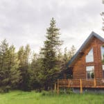
Owning acres of rural property with complete privacy from your neighbors is alluring to many Southern Oregon residents. Whether you’re searching for a rolling countryside or evergreen tree-filled forest, there’s abundant rural property available for everyone. Yet, owning rural property for the first time can be an eye-opening experience. Urban dwellers may not anticipate some […]