• Skip to main content
  • Skip to primary sidebar
logo white outline
  • Phone: (541) 773-2646

  • Phone: (541) 773-2646

logo white outline
Menu
  • Home
  • Services
  • Applications
  • Company
  • Staff
  • FAQs
  • News
  • Maps
  • Links

GIS and GPS Mapping

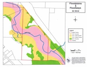
Example of floodplains
Floodplain & Floodway

Richard Stevens & Associates, Inc. has the latest technology to prepare accurate, detailed, high-quality maps using GIS and GPS. All land use applications require some mapping, and using our GIS information, obtained through Jackson County, allows us to demonstrate proposals or issues affiliated with each property. When used in combination with our portable GPS unit, our site visits help us gather valuable information, which we combine with the GIS data to make required maps for land use applications. This process assists us in providing a complete property analysis for the land use application process.

sidebar

up

244 S. Grape Street 
PO Box 4368, Medford OR, 97501

Phone: (541) 773-2646

Fax: (541) 858-8947

  • Home
  • Services
  • Applications
  • Company
  • Staff
  • FAQs
  • News
  • Maps
  • Links

© Copyright 2025 Richard Stevens & Associates, Inc. • Custom Web Design by Paradux Media Group